| |
![]()
 USA Risk
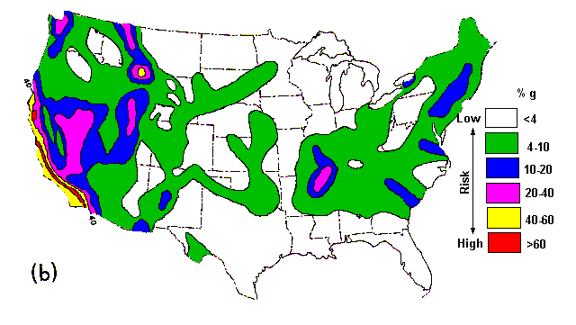
The earthquake hazard in the United States has been estimated in a variety of ways. Chief among them is the production of "risk maps." Such maps prove useful in establishing building codes, engineering design standards, and insurance rates in areas of high risk. Seismic risk maps are based either on relative risk or on the probability of a certain seismic event at a particular time and place.
Two examples of risk maps are shown in this map, which shows four zones that are assigned risk on a relative scale. The maps below are based on the known occurrence of damaging earthquakes in the past, evidence of strain release, and consideration of major geologic structures and provinces believed to be associated with earthquake activity.
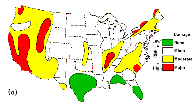
 Earthquake risk maps of the United States: (a) Relative risk of damage, based to a large extent on known
earthquake history (Algermissen, 1969).(b) Probabilistic risk map showing maximum horizontal ground
acceleration with a 90-percent probability of not being exceeded in 50 years (Algermissen et al., 1982).
Earthquake risk maps of the United States: (a) Relative risk of damage, based to a large extent on known
earthquake history (Algermissen, 1969).(b) Probabilistic risk map showing maximum horizontal ground
acceleration with a 90-percent probability of not being exceeded in 50 years (Algermissen et al., 1982).
Offered by Brand.
