Texas Horror
In the Safe Locations information, the Zetas describe Texas has having an inordinate amount of water washing
over it during the hour of the pole shift. Many have questioned this, stating that the high plains are at such a
distance from the coastline and at such an elevation that the sloshing Gulf could not Ppossibly reach the high
plains.
ZetaTalk Prediction 2001: For Texas, this means that the water will lap at the foothills of the Rockies,
before dying back. Texas will be devastated by waters sloshing in from the Gulf during the pole shift.
Being flat land, and low, the Gulf will roll over Texas without opposition, at a height of several feet.
Texas, due to its flat terrain, will get more water overall than neighboring areas. Even the high plains
will have several feet of water moving across it, where the coastal areas will have tidal waves hundreds
of feet high.
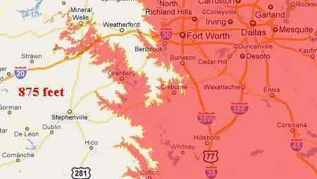
Then there is the explanation by the Zetas for the Stephenville UFO. They stated that the drowning from Dallas
would crawl up onto the high land of Stephenville. Yet a 875 foot deep flood would have to be occurring for
this situation to exist!
ZetaTalk Prediction 1/19/2008:Stephenville has a high elevation in its immediate area. Checking a
topography map one sees that rivers flow from and around the area. Compared to the Dallas area, in
which rivers flow through, Stephenville will be dry when Dallas is flooded. Texas will be flooded all the
way to the highlands of the north and west, to an extent not considered possible by the residents of
Texas. Dallas will be flooded, for weeks, until the waters slowly drain, forcing the residents to clamor
into highrises to survive.
The Texas high country starts at the Balcones Escarpment. Cities such as Austin and San Antonio are right on
the edge of this escarpment.
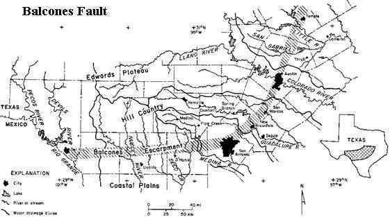
- http://voicesofthetexashills.org/vthgeology.htm
- The Balcones fault zone is an extensive group of faults that transects Texas on a generally
southwest to northeast line, and extends into Louisiana and Arkansas. The Balcones fault is
marked by the Balcones Escarpment, an abrupt change of elevation in the terrain that extends
from Del Rio, through Brackettville, Uvalde, the northern parts of San Antonio, and then
northeastward through New Braunfels, San Marcos, Austin, Georgetown, Salado, and Temple.
The change in elevation of the terrain is quite abrupt, with the terrain north of the fault ranging
from 1,000 to 2,000 feet above sea level. South of the Balcones Escarpment, the terrain is
generally 600 feet above sea level or lower, declining gently for about 150 miles to the coast of
the Gulf of Mexico.
Per the Zetas, it is the crushing of the Caribbean by the S American Plate crunching up against the N American
Plate will compress the water in the Gulf, which will rush up over Texas. And yes, up the ravines in the
escarpment and over the high plains to some degree!
ZetaTalk Explanation 10/2/2010: The devastation to Texas has, until this moment, come in bits and
pieces of ZetaTalk. We early made the statement that the water will roll across Texas even to "lap at
the foothills of the Rockies". Our statement was also that Dallas would be flooded for weeks, and the
UFO warnings about Stephenville getting the drowning from Dallas crawling up on their shore
reiterated that. Our statements on the degree to which Texas will be flooded have been ridiculed, but
have consistency. Maps of the area showing where a water height of 875 feet show our predictions as
possible at this height. Why would we not merely warn Texans that the tidal wave along their shores
was going to be 875 feet? In our experience, it is better to move to the next level, explaining what this
means to man, who else does not engage the reality of the message. To state what cities will be flooded
and how far the water will push gets their attention, where a mere number does not.
Why will Texas suffer in this regard when the rest of the world is to receive sloshing of 500-600 feet
along their coasts during the hour of the pole shift? The S American Plate will crush the Caribbean
during the hour of the shift, moving through this small plate to collide with the N American Plate, in
essence. Where does the water in the Gulf go during this process? Of course it will pushes over Florida
and along the Gulf states, who are anticipating the sloshing and 150 foot drop in elevation for Florida
and the southeastern US to require them to be in the Appalachian mountains or foothills for safety. But
Texas, as we have stated, is flat land, and offers no resistance to a wall of water on the move. Water
will funnel there, finding resistance elsewhere. The Balcones Escarpment which swaths across Texas in
a curve is the point where the wave will break. Here the cities of Austin and San Antonio will find
themselves flooded but not at a great depth. The force of water will push beyond the escarpment where
ravines allow the press of water to move forward, rushing over the high plains in places.
Trimesters Confirmed
In the Fall of 2009 NASA announced they had discovered a "magnetic ribbon" at the edge of the solar system,
confirming what the Zetas have always said about our solar system and the Sun being caught in a LARGER
magnetic field that dominates the vicinity. Something the Zetas, and the Zetas alone, have always asserted.
- NASA's IBEX Spots Mystery Emissions at Edge of Solar System
October 15, 2009
http://www.foxnews.com/story/0,2933,567020,00.html
- "[The ribbon is] aligned by and dominated by the external magnetic field," McComas said in a
briefing Thursday. "That's a huge clue as to what's going on. But still we're missing some really
fundamental aspect of the interaction - some fundamental physics is missing from our
understanding." The new IBEX results will be published in the Oct. 16 issue of the journal
Science.
ZetaTalk Statement 2/15/1996: A planet's magnetic influence is not encapsulated by its crust, but
reaches beyond this even to the ends of the solar system.
ZetaTalk Comment 6/6/2004: Why is it the Sun, as the giant magnet dominating the solar system, points
North and South with its poles in the directions it does? For those late to this argument, the Sun does
not reverse polarity every 11 years as NASA states, and the solar magnetic field reaches beyond the
outer bounds of the solar system, affecting all the planets. The Sun likewise is under the dictates of
influences that surround it, and as the Sun goes, so go the planets.
NASA's IBEX provided its first map a year ago, October 15, 2009, with a second provided Spring of 2010
and the third just recently available. NASA is declaring that changes occur within the magnetic ribbon within a
six month period. They are not sure of the exact timing, as they only get a map every six months, but they are
sure that the change happened with a six month period!
- Knot in the Ribbon at the Edge of the Solar System "Unties"
September 29
http://www.swri.org/9what/releases/2010/knot.htm
- The unusual "knot" in the bright, narrow ribbon of neutral atoms emanating in from the
boundary between our solar system and interstellar space appears to have "untied," according to
a paper published online in the Journal of Geophysical Research. Researchers believe the ribbon,
first revealed in maps produced by NASA's Interstellar Boundary Explorer (IBEX) spacecraft,
forms in response to interactions between interstellar space and the heliosphere, the protective
bubble in which the Earth and other planets reside. Sensitive neutral atom detectors aboard IBEX
produce global maps of this region every six months.
The Zetas have long stated that magnetic trimesters exist, ending at approximately the end of December, April,
and August. The strongest of these is the Summer trimester. This issue was covered last October 25, 2010 in
Issue 156 of this newsletter.
ZetaTalk Explanation 12/30/2006: Since magnetism is viewed as polarized, a N Pole and a S Pole, with
particles flowing from one to the other, the idea that there would be trimesters is confusing. We have
explained that the Sun's magnetism reaches to the ends of the solar system and beyond, and dominates.
Mercury and Earth, for instance, align with the Sun's permanent alignment, and for those who say the
Sun flops about, reversing fields every 11 years, NASA's own Ulysses probe proved them wrong in 2001.
Imagine the solar system itself aligned along a magnetic flow line of a larger field, which pulses. It is no
accident that the Earth, a magnetic planet, is going round the Sun every 365 days or so, as the magnetic
trimesters have something to do with this progression.
NASA scientists are citing as one evidence of change from one map to another the unraveling of a "knot" in the
magnetic ribbon. All of this astonishes and confuses NASA, but the Zetas knew.

- Knot in the Ribbon at the Edge of the Solar System "Unties"
September 29
http://www.swri.org/9what/releases/2010/knot.htm
- Analyses of the first map, released last fall, suggest the ribbon is somehow ordered by the
direction of the local interstellar magnetic field outside the heliosphere, influencing the structure
of the heliosphere more than researchers had previously believed. The knot feature seen in the
northern portion of the ribbon in the first map stood apart from the rest of the ribbon as the
brightest feature at higher energies. While the second map, released publicly with the
just-published paper, shows the large-scale structure of the ribbon to be generally stable within
the six-month period, changes are also apparent. The polar regions of the ribbon display lower
emissions and the knot diminishes by as much as a third and appears to "untie" as it spreads out
to both lower and higher latitudes.
World Awash
As the Zetas predicted in 1995, the world would experience intractable drought and deluge, which would
switch about for no apparent reason.
ZetaTalk Prediction 7/15/1995: Mankind will find its greatest problems with the weather to be its
unpredictability. Areas of the world which have been deserts throughout mankind's memory will become
swamps under constant and repeated rains. Temperate climates used to periodic gentle rainfall will
suffer intractable droughts. Then this will switch about, for no apparent reason.
Recent flooding in Mexico and Germany highlight the state of affairs.
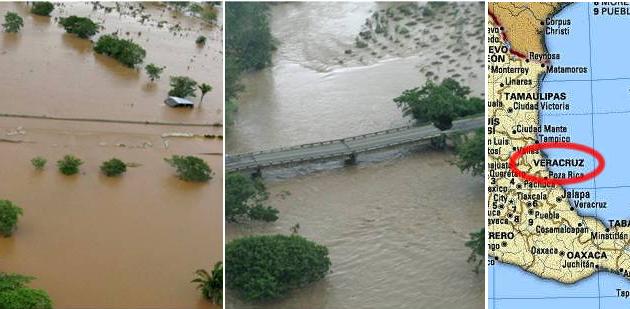
- Floods Leave Families in Peril in Mexico
October 02, 2010
http://articles.cnn.com/2010-10-02/world/mexico.flooding
- Mexico declared 15 more municipalities disaster areas as the country deals with major flooding
caused by tropical cyclones that recently battered the area, according to state media.
The flooding in Mexico also affected the Oaxaca region, which experienced a horrific mudslide. At first, it was
feared this had killed hundreds.
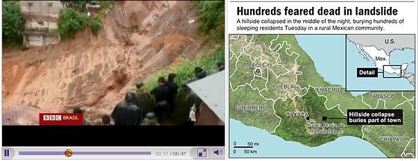
- Mexico Landslide less Deadly than Feared
September 29, 2010
http://www.alertnet.org/thenews/newsdesk/N28166004.htm
- A landslide in a remote mountain town sent Mexican authorities scrambling to deploy rescue
workers, but initial reports that hundreds were buried proved overblown.
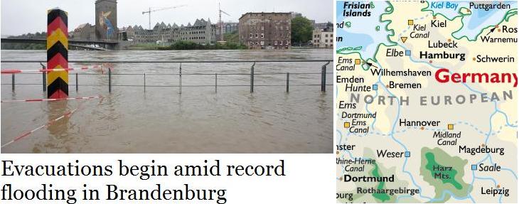
Where flooding in Mexico is related to tropical storms, flooding also occurred at the same time in Brandenburg,
Germany. Coincidentally, the Zetas just recently answered a question about UFO sightings in Brandenburg,
citing its vulnerability to flooding as the warning!
VIDEO: Brandenburg UFOs
- Flood - Europe - Germany
September 29, 2010
http://www.ubalert.com/a/29967
- Emergency services in Brandenburg are preparing to evacuate the towns of Elsterwerda and Bad
Liebenwerda amid flooding caused by record high water levels on the Elster River.
During the August 21, 2010 Q&A session, the Zetas addressed the UFO message given to Brandenburg. The
warning? Brandenburg is vulnerable to extreme flooding.
ZetaTalk Prediction 8/21/2010: As man is well aware, a blinking or pulsing light gets more attention.
The times are coming closer when major Earth changes, such as the European tsunami, will be upon
mankind, and those making UFO displays are trying to get more pointed, so to speak, in their warnings.
This is what these two UFO displays, a world apart, have in common. So do they have a common
message? The YouTube on Guadalajara's display mentioned that at one point the light pointed to a
ravine. Guadalajara is positioned such that tidal bore from the Pacific would reach this mountain city,
despite its elevation. Water will reach the streets of Guadalajara, to the astonishment of its citizens.
Likewise for the Brandenburg, Germany display. This city, east of Hanover on the juncture of the
Midland Canal and the Elbe River, will find itself awash during the European tsunami despite being 100
miles from the Baltic Sea and twice as far from the North Sea. Both the Elbe River and the canal will
deliver the force of water to Brandenburg, where they will clash and roil. This part of Germany should
not be complacent!
You received this Newsletter because you Subscribed to the ZetaTalk Newsletter service. If undesired, you can quickly
Unsubscribe. You can always access prior Newsletters from the Archives.
|