Frankenstorm
Cause
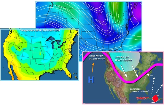
Sandy was branded a Frankenstorm, or a hybrid storm, because
where it was only a Category 1 hurricane, it was expected to
collide with multiple high pressure areas, cold fronts to the
North and West of its path, and thus as Sandy (as all hurricanes
are) was a low pressure area, it would be forced to turn into
the coastline, seeking the path of least resistance.
- Worst Storm in 100 Years Seen Headed
for Northeast U.S.
October 26, 2012
http://www.businessweek.com/news/2012-10-25/u-dot-s-dot-east-from-washington-to-nyc
- Hurricane Sandy will probably grow
into a “Frankenstorm” that may become the worst to hit the
U.S. Northeast in 100 years if current forecasts are
correct. Sandy may combine with a second storm coming out
of the Midwest to create a system that would rival the New
England hurricane of 1938 in intensity. Computer
models suggest the hurricane may transform into a hybrid
system over the weekend because of another storm moving in
from the Midwest. The 1938 hurricane killed more than 500
people after crossing Long Island and battering
Connecticut and Rhode Island.
- Frankenstorm 2012: Hurricane Sandy
Hybrid Could Hit New York, New Jersey And Pennsylvania
October 26, 2012
http://www.huffingtonpost.com/2012/10/26/frankenstorm-2012-hurricane-sandy_n_2022333.htm
- Will a Hurricane Sandy, winter
storm hybrid, dubbed a "Frankenstorm" by the National
Oceanic and Atmospheric Administration, ravage the U.S.
East Coast? Climate Central reported that the jet stream
winds boxing in Sandy and creating a "Frankenstorm" are
part of "blocking patterns [which] have appeared with
greater frequency and intensity in recent years."
Meteorologists stated that Sandy would be “boxed in” as
“blocking patterns” have apparently appeared in recent years. Is
this another way of describing the Earth wobble? When the Sun is
high over Italy, the globe has a lean so that air in the North
Atlantic is compressed. But during the day in the US, when
the Sun is high over North America, the North Atlantic is pulled
down away from the Arctic air, easing that compression. This has
been described as a pumping action, or a vertical jet stream.
Then when the Sun is centered over the Pacific, pushing the N
Pole away from Planet X, the air will again be compressed over
the North Atlantic. But a few hours later, when the Sun is over
India, once again the North Atlantic gets relief. Some of this
would indeed tend to “box in” Sandy.
Computer models predicted landfall, and mandatory evacuations in
low lying areas were ordered by the New York City mayor. Though
only a Category 1 hurricane, Sandy was immense, and the storm
surge was expected to produce immense flooding as a result.
Thought hurricanes turning inland along the northern coastline
of the US were rare, history had shown that New York City, the
largest city in the US, could be flooded by such storms, with
great loss of life.
- NYC Evacuations Begin Over Hurricane
Sandy; Public Schools Closed
October 28, 201
http://www.huffingtonpost.com/2012/10/28/nyc-evacuations
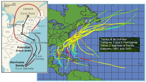
- New York City announced the
closings of its mass transit and school systems, both the
nation's largest, and ordered residents to leave some
low-lying areas Sunday ahead of the massive storm
approaching the eastern third of the U.S. Hurricane Sandy
was headed north from the Caribbean to meet both a
snowstorm and a cold front, and experts said the rare
hybrid storm that results will cause havoc over 800 miles
from the East Coast to the Great Lakes. A storm surge of 6
to 11 feet was expected. Mayor Michael Bloomberg ordered
an evacuation of the low-lying areas along the edges of
the city, including parts of lower Manhattan like Battery
Park City and some of the financial district, sections of
Brooklyn and Staten Island and the Rockaways in Queens.
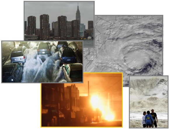
The impact on the New Jersey coastline was as bad as expected,
water washing up the streets of New York City, into the subways,
and the power shut down in the city to prevent damage to the
system. Despite the torrential rain, fires broke out and were
out of control.
- Mammoth Storm Sandy Plunges NYC into
Darkness
October 30, 2012
http://hosted.ap.org/dynamic/stories/U/US_SUPERSTORM_NYC
- The city had shut its mass transit
system, schools, the stock exchange and Broadway and
ordered hundreds of thousands of New Yorkers to leave
home. Utilities deliberately darkened part of downtown
Manhattan to avoid storm damage.
- At Least 50 Flooded Houses Destroyed
by NYC Fire
October 30, 2012
http://news.yahoo.com/least-50-flooded-houses-destroyed-nyc-fire-085028999.html
- A huge fire has destroyed at least
50 homes in a flooded neighborhood in the New York City
borough of Queens. Video footage of the scene shows a
hellish swath of tightly packed homes fully engulfed in
orange flames as firefighters hauled hoses while sloshing
in ankle-high water.
As bad as this disaster was, it is nothing compared to what is
coming during the hour of the Pole Shift or in the Last Weeks
during the Severe Wobble. This Frankenstorm did not include
earthquake damage, which will be present during the Pole Shift
and during the lurching of the Severe Wobble. The Zetas have
always warned that fires are one of the biggest dangers for
those remaining in the cities. Frankenstorm Sandy certainly
echoed that warning.
ZetaTalk Warning
2001: Heavily
populated areas have several drawbacks during times of crisis
such as the coming cataclysms will bring. However well
prepared a given family may be, they are never prepared for
what their neighbors will bring to them. New York City is one
of the most heavily populated areas, and by being a coastal
city, has additional strikes against it. For many, on islands
along the coast supported by a system of bridges that have
been torn apart, they will have no escape. Tall buildings will
bash into each other during the seemingly endless earthquakes,
which they were scarcely designed to withstand. Fires and the
howls of the injured and desperate make travel through such a
devastated area literally life threatening. Those who stay in
New York City during the coming cataclysms are either ignorant
of what is about to occur, courageous, or harboring a death
wish!
Will Frankenstorms continue? Per the Zetas the wobble is
becoming more severe. Living along the coastlines will become
increasingly hazardous.
ZetaTalk Warning
2/4/2012: There
has been no change in the wobble pattern, the wobble has
merely become more severe. The pattern of the Figure 8
remained essentially the same.
ZetaTalk Warning
10/30/2012: As
with Irene in 2011, hurricanes running up the East Coast of
the US are being affected by the Earth wobble to the point of
being noticeable in their path veer. The upper Atlantic is no
longer welcoming for these low pressure areas, which choose
rather to move inland in the US where the heat of the Earth
has created upward convection of air. Arctic air, chilled and
thus high pressure zones, has been pushed down from the Arctic
over the Atlantic, blocking the path of these hurricanes on
occasion.
What will this mean for the
future? We have stated that the wobble will worsen, to the
point that the seasons will blend into one another. We have
stated that many coastlines will eventually become unlivable,
being used to grow crops only, as the Last Weeks approach.
Wobble sloshing during the Last Weeks will not be slight, but
bring tides up to 200-300 feet running N/S as the globe slings
back and forth prior to a firm lean to the left. Those
horrified by what Hurricane Sandy has done to the East Coast
of the US are being encouraged, by Mother Nature, to leave the
cities early. Why linger?
Cylindrical UFO Duet
An amateur astronomer in Kentucky managed to videotape a
cylindrical UFO in great clarity on October 16, 2012, and just
when this was hitting the press on October 24, 2012 yet another
instance hit the press. A TV station cam fixed on the
Popocatepetl volcano also
caught a cylindrical UFO plunging into the volcano cone. Per the
Zetas, this duet was designed to get UFOs into the news.

- Cylindrical UFO Videotaped By Kentucky
Amateur Astronomer Allen EplingE
October 24, 2012
http://www.huffingtonpost.com/2012/10/24/cylindrical-ufo-videotaped-amateur-astronomer
- Several eyewitnesses in different
areas of eastern Kentucky reported seeing a strange,
cylindrical UFO hover for two hours in clear skies last
week, but an amateur astronomer's striking video and
images of the object are now coming to light.
- Light on the Phenomenon of
Popocatepetl
October. 26, 2012
http://noticierostelevisa.esmas.com/nacional/518179/fenomeno-luz-popocatepetl/
- The House that Televisa has
permanently recording the activity of the volcano
Popocatepetl caught the moment that in a down light and
apparently introduced themselves inside the giant crater.
Approximately kilometer long by 200 meters wide, you can
not appreciate where it comes from, but with a speed seems
aircraft entering the crater. Is a cylindrical body, shows
no excess shine on its front face and shadow. We went with
the astronomer at UNAM, a member of the International
Astronomical Union. The Scientific trarse precludes the
possibility of it be a meteorite. The attention of
astronomers certain characteristics of this object, first
you have a clean line.
ZetaTalk Comment
11/3/2012: It
is not by accident that a cylindrical UFO was captured in
clear skies by an amateur astronomer over Kentucky, while
being seen by numerous others in the vicinity, and captured by
an official video cam pointed at Popocatepetl. UFOs visit
volcanoes, as we have stated, to determine their status, and
are not affected by the intense heat as would man-made
devices. Normally, a smaller UFO in a more typical shape
is used – round or saucer shaped. The drama this time was
employed so as to get into the news. The clarity of the photos
and video taken by the Kentucky astronomer prove this not to
be a weather balloon or falling piece of space junk, as it
hovered without moving. Likewise as an object plunging
into the volcano, it fell outside of what would be expected –
a meteor or a hunk of lava being spat out of the volcano. Both
issues happening in close succession allow for greater press
coverage, which was the plan.
The Zetas indeed described the activity of UFOs inspecting
volcanos, early in the ZetaTalk sage in 1995. The Zetas stated
they are taking the measure of the state of the lava below. Just
as taking a pulse can relay information about the state of the
heart, this is a quick way to determine what the roiling lava is
doing.
ZetaTalk Description
11/15/1995: The
Earth increasingly shows signs of responding to her brother,
Planet X. In addition to unpredictable and extreme weather and
increasing earthquake activity, emissions from active
volcanoes change in subtle but detectable ways. These
emissions give an accurate measure to those who know how to
read them. As alien groups in the Service-to-Other are in
residence in 3rd Density on the face of your planet, they have
an obvious interest in violent geological changes that will
tear up their temporary homes. These groups monitor volcanic
emissions, both in lava composition and particles in the air,
to better predict in the short-term when earthquakes or
volcanic eruptions will occur. The rumors that UFO sightings
occur frequently near active volcanoes is, therefore, true.
Cylinder shaped UFOs are nothing new. A famous UFO case from
1985, which has never been debunked, remains “unsolved” by the
authorities.
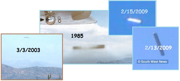
- UFO Over Mojave Desert Sept. 9, 1985
http://www.huffingtonpost.com/2012/10/24/cylindrical-ufo
- This cigar-shaped UFO was
photographed by general aviation pilot David Hastings as
he piloted a Cessna Skymaster plane over the Mojave Desert
on Sept. 9, 1985. There has never been an indication of
hoax in this case, which remains unexplained to this day.
- Filer's Files #22 -2009
May 27, 2009
http://www.nationalufocenter.com/artman/publish/article_280.php
- I was with my father on March 3,
2003, and took a picture of the landscape at that time saw
nothing, but when we saw the photo in more detail we saw
that it was something strange.
- Filer's Files #8 – 2009
February 18, 2009
http://www.nationalufocenter.com/artman/publish/article_264.php
- On February 15, 2009, A cylinder
shaped object was captured while looking at Phoenix
Webcams. Object below is enlarged cylinder. Note this
object is similar to cylinder filmed over the UK.
- Mystery Cylinder UFO Spotted over
British Holiday Resort
February 13 2009
http://www.thetechherald.com/articles/Mystery-cylinder-UFO-spotted-over-British-holiday-resort
- During the handheld video, the
person behind the camera struggles to track what appears
to be an elongated gunmetal-grey cylindrical shape that’s
moving across the sky and is barely visible to the
camera’s lens without performing an extreme zoom. Not
alone in watching the strange shape, a number of fellow
caravan occupants on the holiday site in Brean, Somerset,
witnessed the UFO as it moved about in the blue July sky.
Sunda Soggy
Though the Sunda Plate had already sunk
to the level predicted by the Zetas during the 7 of 10
plate movements, the Sunda Plate continues to get more soggy.
From Vietnam,
Cambodia,
Thailand,
and the islands near
Fiji. Where the sinking during 2011 and 2012 was explained
by the establishment as due to rain, the claim now is “climate
change” with “rising seas”, as though rising seas would only
affect SE Asia and the South Seas and not the beaches elsewhere
around the world.
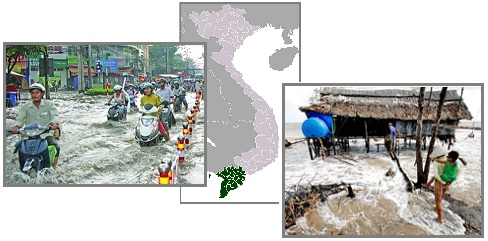
- Sea Change
October 25, 2012
http://talkvietnam.com/2012/10/sea-change/comment-page-1/
- Rising sea levels and land sinkage
are proving to be a double-whammy in the Mekong Delta,
where residents are constantly forced to raise their homes
to remain above water. Around 20,000 hectares of farmland
are submerged during high tide now, twice the 2007 level.
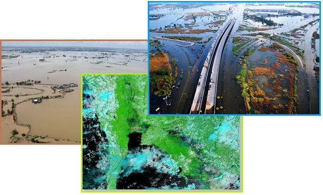
- 1,000 Cambodian Families Evacuated Due
to Floods
September 19, 2012
http://vov.vn/The-gioi/Gan-1000-gia-dinh-Campuchia-so-tan-do-lu-lut/225492.vov
- Cambodian Disaster Management
Agency, 2011, severe flooding in the provinces of Siem
Reap along the Mekong River and killed 250 people and
affected nearly 500,000 families. Nearly 1/5 of rice
destroyed.
- Thai Opposition & Government Blame
each other for Flood Mismanagement ?
September 23, 2012
http://presstv.com/detail/2012/09/23/263116/thaioppositiongovernmentmismanagement/
- In Thailand, 15 provinces have
been declared disaster flood zones. Work crews took a long
time to drain off the water because subsidence in the city
means the canals now have only a gradual drop and the
water flows out much more slowly.
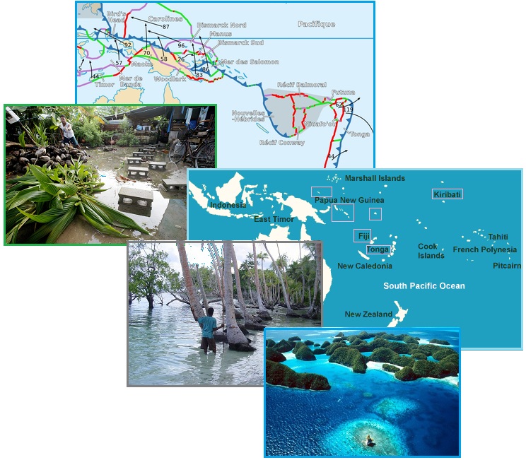
- 11 Islands That Will Vanish When Sea
Levels Rise
October 1, 2012
http://www.businessinsider.com/islands-threatened-by-climate-change-2012-10?op=1
- The Solomon Islands are east of
Papua New Guinea, and have a population of 584,578. A team
of French researchers have been monitoring the island of
Vanikoro, part of the 992 islands that make up the island
chain, because they think it is slowly sinking. The team
placed a survey marker a safe distance from the beach, and
seven years later it was underwater. After what is know
about Tegua the researchers found that along with rising
sea levels, this particular island is also sinking.
Micronesia is made up of 607 mountainous islands and
low-lying coral atolls and is being eroded away by rising
sea levels. Palau consists of eight principal islands and
more than 250 smaller ones, about 500 miles southeast of
the Philippines. Their population of 20,000 is being
threatened by rising sea levels.
All this was predicted by the Zetas, who cite the scripted
drama of the plate movements – the Pacific Plate being pulled
under the eastern edge of the Indo-Australian Plate, which is
rising. The little platelet that holds Fiji in particular will
suffer in this crunch.
ZetaTalk Prediction
1/15/2011: Samoa
rides on the Pacific Plate, which is pushing under the eastern
edge of the Indo-Australian Plate, and as this process
continues and accelerates, approaching the pole shift, will
virtually disappear. The Solomon Islands do not fare much
better, for the same reasons. Tonga and New Caledonia ride
high. The little Fiji Plate, as the recent sinking indicates,
will be a loser, pushed down into the notch as the Pacific
Plate presses ever westward.
Spain Cracking
The African roll, per the Zetas, will pull Gibraltar 125 miles
further apart, and open up a 50 mile divide at the Sinai. These
changes have not shown up, to date, on the MODIS satellite
images, though the African Rift valley and internet
cables torn along the east coast reflect the roll, as
does excessive flooding in Nigeria and the restless
Canary Islands. But Spain is certainly showing the stress
along the plate border in the Mediterranean. A giant
crack developed along the southern coastline. Per the
Zetas, the plate border above Algeria is the most vulnerable
part of the Mediterranean during the African roll.
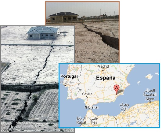
- Spain: Land Crack 1.5 Kilometers
Opened
October 18, 2012
http://www.abc.es/20121018/local-murcia/abci-grieta-esparragal-inundacion-201210181234.html
- Land crack 1.5 kilometers in
length opened after the recession of water in
flood-affected areas of El Esparragal, Puerto Lumbreras.
Depth ranges from 2 up to 5 metres. The most surprised was
the owner of one of the estates, which now is divided. No
conclusions yet no. None of the advising technical
personnel does not dare to determine, could this happen in
consequence the fault line or be the result of extensive
groundwater extractions.
ZetaTalk Prediction
10/16/2010: The
fact that the African Plate, during previous rolls, created
mountain building can be seen on a relief map. Morocco and
Algeria have mountains due to the rolling in the past. One can
see in the mountains of Spain and Italy and the Balcans and
Turkey that this was the case there, too, in the past. The
Alps themselves were built during previous African rolls. But
this time the African Plate will drop away significantly,
slipping to the south during the roll. The border of the
African Plate slices across northern Algeria, and thus when
the plate rolls and drops, the Mediterranean floor there will
suddenly find itself unsupported. Where the land mass housing
Morocco and Algeria will not lose elevation, in the main,
retaining its floatation strength to ride on the magma
beneath, the floor of the Mediterranean is of a different
composition. It will sink there, unsupported on the African
side where the plates will pull apart. The roll of the African
Plate during the 7 of 10 scenarios thus spares all but the
Mediterranean floor above Algeria!
|