|
Korea Ferry Disaster
What caused the Korean ferry Sewol to tilt and swamp in the
cold seas in the early morning hours of April 15, 2014? Since
there was no hole in the hull, the tilt was blamed on a sharp
turn of the wheel causing cargo to shift. Per the Zetas, this is
another case of a ship disaster caused by the violent daily
Earth wobble.
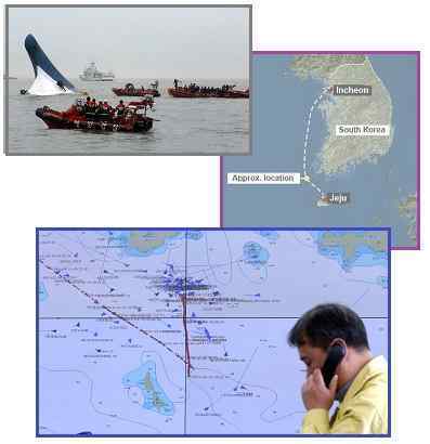
- Six Dead, 290 Missing in S. Korea
Ferry Sinking
April 16, 2014
http://news.yahoo.com/two-dead-368-rescued-capsized-korea-ferry
- The cause of the accident was not
immediately clear, although rescued passengers reported
the ferry coming to a sudden, shuddering halt - indicating
it may have run aground.
- South Korea Investigates Ferry
Captain; 9 Dead, 287 Missing
April 17, 2014
http://finance.yahoo.com/news/south-korea-investigates-ferry-captain
- The ferry listed and capsized in
an area of the ocean as shallow as 20 meters (66 feet) in
some parts, based on readings from a coast guard vessel
used in the rescue operation. The ferry appears to have
sailed on the route approved by the coast guard. The coast
guard received the accident alert from the ferry at 8:58
am.
- South Korea Ferry Disaster: Rapid
Direction Change, Route Deviation may be Cause
April 17, 2014
http://www.straitstimes.com/the-big-story/south-korea-ferry-sinking
- The Coast Guard investigators
suspect that the ship changed directly too quickly,
causing cargo to come loose and push the vessel off
balance. The site of the accident is said to be near the
point where ships on the Incheon-Jejudo route change
directions.
The Sewol only appeared to have turned sharply north, as it
was pushed in that direction and tipped by a tide caused by the
Earth wobble, a type of localized tsunami. Water moves
independently from the land. When the daily polar
push shoves the Earth’s N Pole back over the horizon, the
land moves, but the seas do not. This creates a void along the
coastline facing the south, until the seas rush back in to fill
the void. Where this would merely be a strong tide along a
smooth coastline, in a region of small islands and rocky
outcroppings, the tides swirl about, rushing this way and that.
The Zetas explain.
ZetaTalk Explanation
4/19/2014: Why
was the Sewol thrown north from its channel when the polar
push is throwing the land under the water to the north? Would
the ferry, floating on the water, not find itself on water to
the south? There is a reaction in displaced water, especially
along a coastline where a void can form. As Korea moved north,
the water, which is independent from the land, remained in
place, creating a temporary void along the coastline. The
water to the south then rushed in a strong tide to fill this
void, carrying the ferry with it like so much flotsam on the
water. The Sewol disaster will be blamed on shifting cargo,
ultimately blamed on the crew, as the Earth wobble cannot yet
be explained by the establishment.
Two prior incidents that hit the news were also caused by the
Earth wobble, though this was never officially admitted. The Costa Concordia cruise ship found the
ground suddenly moving under
the ship on January 15, 2012. The Costa Concordia was in the bay
to the south of the rock, when the rock suddenly moved under it.
The Costa Concordia accident occurred at 8:00 pm, when the polar
push was happening on the opposite side of the globe. If Korea
finds the globe suddenly moving northward, Italy finds it
suddenly moving southward.
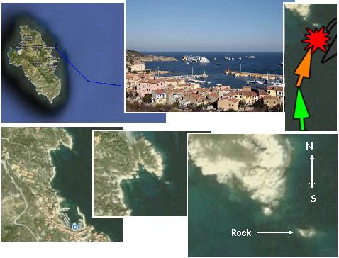
ZetaTalk Explanation
1/21/2012: Europe
also participates when the most violent push of the wobble
occurs, when the Sun is high over the Pacific and Europe is in
the dead of night. The globe is pushed violently north as the
magnetic N Pole of Earth comes up over the horizon and is
pushed away by Planet X. When this happens the globe is pushed
southward on the opposite side of the globe, as the globe
rolls as one. What does this do to the rocky shores of Italy
and any hapless ships moored or traveling just off the coast?
The land is pushed under the water, and the ship suddenly
finds itself on rocks it thought safely at a distance.
The Sewol incident is also not the first for Korea. On January
15, 2012, the same day as the Costa Concordia accident, an oil
tanker was thrown against the rocks along the southwest
coastline of S Korea just north of Jawol
Island. Note the similarity in time with the Sewol
disaster! Jawol Island happened at 8:00 am, and the Sewol
disaster at 8:58 am.
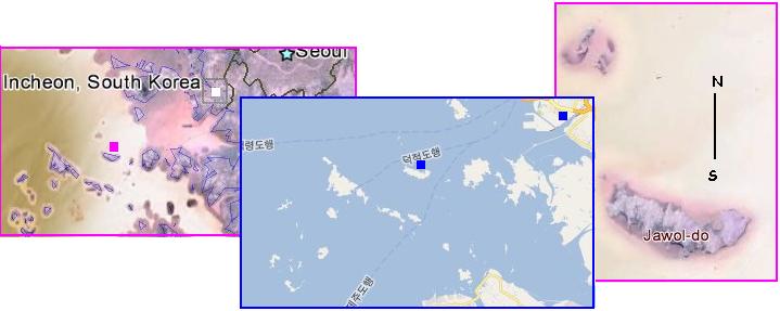
ZetaTalk Explanation
2/4/2012: At
8:00 am in South Korea, the Sun is high over the Pacific, just
the location for the strong polar push of the wobble, sending
the emerging magnetic N Pole of Earth back over the horizon.
This is the time when the globe is shoved north in the Pacific
Rim, which would indeed cause the undersea landscape just 3
miles north of Jawol Island to shove under and tear apart the
oil tanker. This is of course the same global push that
occurred in Italy to the Costa Concordia, when the undersea
landscape moved suddenly south on that side of the globe to
gash its side, late in the evening. On opposite sides of the
globe, on opposite sides of the clock, both victims of the
same global wobble.
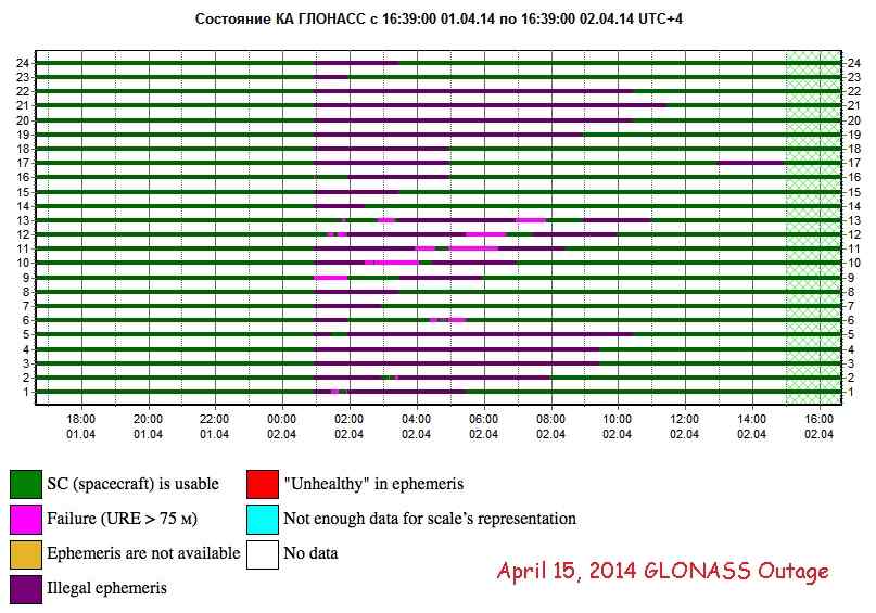
GLONASS Failure
Yet another indication of the increased wobble is the GLONASS
outage. GLONASS is equivalent to the GPS
system maintained by the US, using geostationary
satellites that speak to one another, forming a net around the
globe. GLONASS had an outage on April 2, which hit one or
another of its satellites so that the entire GLONASS network
could not function until these outages ceased. Then on April 15,
another larger outage. That these are repeating outages
indicates that the “human factor” excuse, a programming error,
is a lie, part of a cover-up. Coincidentally, the second outage
on April 15 coincides with the wobble disaster in Korean, the
ferry Sewol tipping over. Per the Zetas, the GLONASS outage is
another piece of evidence that the Earth wobble has increased in
violence and scope.
- GLONASS System has Suffered a Major
Failure
April 15, 2014
http://www.interfax.ru/russia/371646
- Eight satellites Glonass
navigation system both went out for half an hour last
night . This is the second failure in the system from the
beginning of the month. Problems started a few minutes
before the morning on April 15. Spacecraft number number
747, 743, 717, 737, 738, 720, 732 and 735 show signs of
"unhealthy" in their ephemeris (satellite position data in
space). This condition persisted for half an hour, said
the information-analytical center of Roscosmos. This is
the second state of emergency in the GLONASS system in two
weeks. On April it has failed for more than 10 hours.
Spacecraft were given incorrect information about its
location and therefore provide consumers the wrong
navigation information. An error occurred while virtually
all vehicles. As explained by the "Interfax" a source in
the space industry, then the problem was caused by the
"human factor " - the program tab on board vehicles
incorrect data. April 11, it became known that a group of
GLONASS satellites are 22 of the necessary apparatus 24.
Therefore, the system is not yet able to provide coverage
of the entire Earth navigation signal. For uninterrupted
availability of the GLONASS system anywhere in the world
need to work 24 spacecraft. Navigation support for
customers in Russia rather work 18 vehicles.
- GLONASS Gone then Back
April 2, 2014
http://gpsworld.com/glonass-gone-then-back/
- “Bad ephemerides were uploaded to
satellites. Those bad ephemerides became active at 1:00 am
Moscow time,” reported one knowledgeable source. For every
GNSS in orbit, the navigation messages
include ephemeris data, used to calculate the
position of each satellite in orbit, and information about
the time and status of the entire satellite constellation
(almanac); this data is processed by user receivers on the
ground to compute their precise position.
ZetaTalk Insight
4/5/2014: Was
this, as is being reported in some media, merely a bad
ephemerides passed to the satellites or is this a cover story?
It is clear that the mass outage was due to some of the
satellites in the network being disabled, as all must be
operational for the network to operate. But it is also clear
from the graph that satellite failure was transient, and this
failure moved from one satellite to another and did not linger
on an affected satellite. And if a programming error was the
cause, they why did this situation repeat during the month of
April? Were the GLONASS programmers repeatedly drunk?
This GLONASS failure was due
to some of the satellites being affected by the Earth wobble,
moved out of position temporarily by uneven air pressure in
the upper atmosphere caused by layers of the atmosphere being
dragged about by the wobbling globe. Air pressure sorts itself
out in time, high pressure disbursing to low pressure regions,
so the satellite floats back to its assumed position and comes
back online. Else why would a given satellite in the network
be affected, and then not, if its programming were the cause
of an outage?
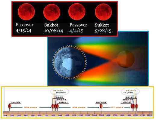
Blood Moons
In yet another coincidence with the April 15, 2014 date, the
first in a series of Blood Moons occurred this on April 15.
Blood Moons are a natural lunar eclipse result, and on occasion
run in a set, as is occurring again for 2014-2015. Jewish
holidays which normally are scheduled around a Full Moon thus
coincide with a Blood Moon, but there is likewise no particular
significance in this synchronicity. Nor, per the Zetas,
are the Blood Moons the blood red moon predicted in the Bible
for the Apocalypse.
- Four Blood Moons: Total Lunar Eclipse
Series Not a Sign of Apocalypse
April 9, 2014
http://www.space.com/25409-four-blood-moons-tetrad-lunar-eclipse.html
- So while a tetrad of total lunar
eclipses is somewhat rare, it is not extraordinarily so,
and probably nothing to make a fuss about. After all, the
only thing that happens during a lunar eclipse is that the
moon spends a couple of hours passing through the Earth's
shadow, hardly something to be concerned about.
- Revelation
6:12-14
- When he opened the sixth seal, I
looked, and behold, there was a great earthquake, and the
sun became black as sackcloth, the full moon became like
blood, and the stars of the sky fell to the earth as the
fig tree sheds its winter fruit when shaken by a gale. The
sky vanished like a scroll that is being rolled up, and
every mountain and island was removed from its place.
- Acts 2:20
- The sun shall be turned to
darkness and the moon to blood, before the day of the Lord
comes, the great and magnificent day.
- Joel 2:31
- The sun shall be turned to
darkness, and the moon to blood, before the great and
awesome day of the Lord comes.
ZetaTalk Comment
4/12/2014: Biblical
verses predict a Blood Moon prior to the next Apocalypse,
which is the pending passage of Nibiru. Given that a passage
involves red dust turning ponds and rivers blood red, and
given that this red dust is wafting about the Earth during the
passage, putting a thick layer in front of the Moon, is this
merely a prophecy depicting the red dust during the Last Weeks
and hour of the Pole Shift? At no point in the Biblical
prophecies is there an indication for a series of Blood Moons.
If anything, the color of the Moon is not described as a
fleeting color, as occurs during an eclipse, but lingering for
days. The Biblical passages are thus not referring to a
series of eclipses in 2014-2015, but to the passage itself.
What is to be made, then, of the Jewish holidays lining up
with the Blood Moons in 2014-2015? Sukkot is a Full Moon
holiday and is scheduled thus for the Full Moon, as is the
Passover. It is not that the Tetrad of Blood Moons magically
lined up with the Jewish holidays, it is that the Jewish
holidays lined up with the Full Moons.
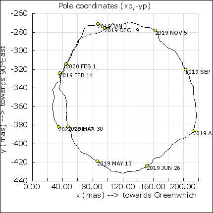
Earth Orientation
Graphs
Since the start of 2014, the mapping of the Earth’s polar
orientation done by IERS has changed. The focal points for
determining the Earth’s x and y coordinates during the year are
on the Meridian and various points on the Equator, as this Japanese
presentation shows.
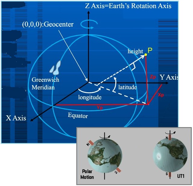
- What is Polar Motion?
http://www.usno.navy.mil/USNO/earth-orientation/eo-info/faq/what-is-pm
- The angles which characterize the
direction of the rotational pole within the Earth are
called the polar coordinates, x and y. Variation in these
coordinates is called polar motion. The polar coordinates
measure the position of the Earth's instantaneous pole of
rotation in a reference frame which is defined by the
adopted locations of terrestrial observatories. The
coordinate x is measured along the 0° (Greenwich) meridian
while the coordinate y is measured along the 90°W
meridian.
- International Earth Rotation Service
(IERS)
August 2004
http://hpiers.obspm.fr/eoppc/bul/bulb/explanatory.html
- The x-axis is in the direction of
the IERS Reference Meridian (IRM), the y-axis is in the
direction 90 degrees West longitude.
The daily Figure 8 of the Earth wobble has a lean to the right
for the N Pole when the Sun is over India, and then a lean to
the left for the N Pole when the Sun is high over Italy. This
leaning has gotten more extreme since the start of 2014. But
primarily it is the polar push, shoving the magnetic N Pole away
when the Sun is high over the Pacific, that has affected IERS.
The tilt of the Earth at this point equates to a Winter posture,
and thus the lingering Polar Vortex experienced by eastern
Canada and the eastern US this past Winter, but the bounce back
of the N Pole and the swings to the right and left smooth out
the overall climate for the globe. A keen eye’d observer notes
that the IERS polar motion graphs show this more extreme wobble,
since the start of 2014.
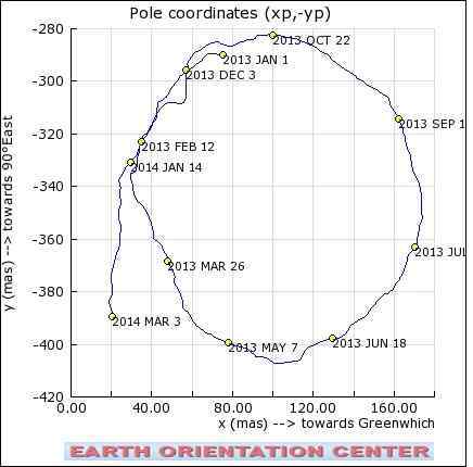
- Would the Zetas like to comment on
the following graph, depicting pole motion over the past
year http://hpiers.obspm.fr/eop-pc/images/pole.png.
According to the graph, there has been a major and
maintained shift since mid January '14 and it doesn't seem
to be self-correcting.
ZetaTalk Comment
4/5/2014: The
polar motion graph presented for our comments is based on X, Y
locations clearly affected by the Earth’s seasons, making a
circle during the year. Since the start of 2014, this circle
has changed shape, indicating that the measurement point has
not pulled southward as the Spring progressed, the Earth’s
geographic N Pole tilting toward the South, but rather
remained as though in Winter. The wobble has worsened, as we
have often mentioned, which means that the daily Figure 8
taken by the magnetic N Pole is pushed farther away, bounces
back more aggressively, and the swings to the right and left
are taking a wider swath.
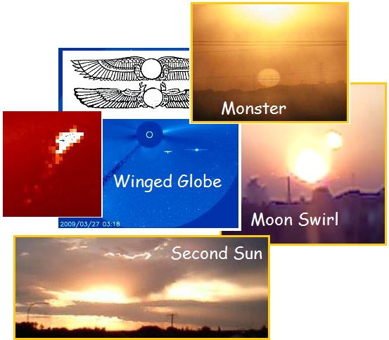
Planet X Looms
Closer
Most photos of the Planet X complex,
regardless of filter, show only the brilliant Moon Swirls which
appear as tubes when viewed from the side and as bright orbs
when seen from the end, the sunlight bouncing down the tube to
emerge at the end. Since 2003 Planet
X itself has only been evident as a Second Sun when sunlight
reflects off the closely shrouding dust cloud at the right angle
at sunrise or sunset, or on occasion as a Monster Sun. Planet X
itself, due to being so heavily shrouded in dust, is rarely
captured in photos.
The Earth is currently in the 8 of 10 posture (with 10 of 10
being the Pole Shift itself) with the increased visibility of
the Planet X complex being predicted by the Zetas for the 8 of
10 evident. This prediction is based on the relative position of
Planet X vs a vs the Earth, where Planet X is seen more to the
right of the Sun, the Earth squeezed as far as possible to the
left, and Planet X having progressed outbound from the Sun, thus
having moved overall closer to the Earth. This movement is
evident in Alberto’s photos since
late March where the tail now has a splayed appearance as
it blows toward the Earth. Per the Zetas, the Earth is
caught within the tail, where formerly was viewing it from
afar.
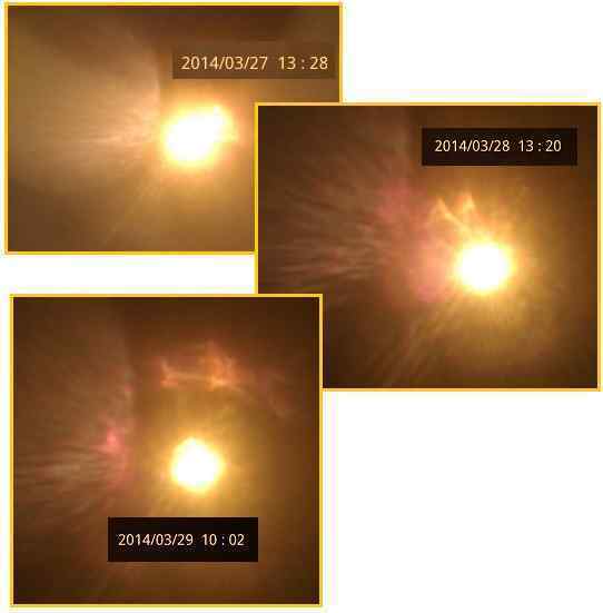
ZetaTalk Insight
4/5/2014: Why
has the appearance of Alberto’s photos changed to show a splay
of the tail directly toward the Earth, rather than slung to
the left as has been the mode for the past few years. When
slung to the side, the tail with its individual Moon Swirls
has been seen as long tubes or as bright orbs when the tubes
were turned to focus light directly toward the Earth. This was
recently apparent in the String of Pearls display, captured by
Alberto. But what would happen if the tail were hosed more
directly at the Earth? The long tubes and bright orbs would
seem to disappear, while the debris in the tail would hose out
in a splay. Imagine a fire hose of water seen from the side,
and then seen when the hose is in your face.
Why has this orientation
changed, between the Earth and Planet X? We explained that
during the 8 of 10, more visibility of Planet X could be
expected. Planet X is approaching the Earth via a retrograde
orbit, clockwise, where the Earth and all the other planets
orbiting the Sun are orbiting in a counterclockwise manner. As
Planet X proceeds past the Sun and outbound, it has pushed the
Earth back in her halted orbit from the December position to
the August position, and the Earth can go no further. While
the Earth squeezes as far to the left as possible, in her
trap, Planet X moves steadily outbound, coming closer to the
Earth. Thus Planet X appears larger, closer, while at the same
time further to the right.
But the most dramatic proof that Planet X is now closer to the
Earth comes from an April 15, 2014 photo capture by Alberto
(using Mylar as a filter) wherein the corpus of Planet X itself
is evident. It is not seen as a brilliant Moon Swirl, but rather
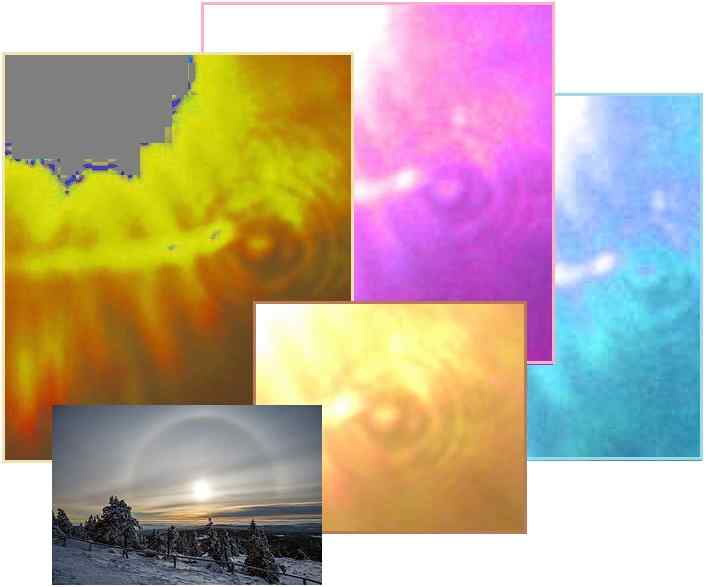
as a heavily shrouded body. The Zetas explain why concentric
rings are seen outbound from this shrouded body. Yet another
April 15, 2014 synchronicity, this photo capture must be added
to the Sewol disaster, the GLONASS outage, and the Blood Moon.
Humm.
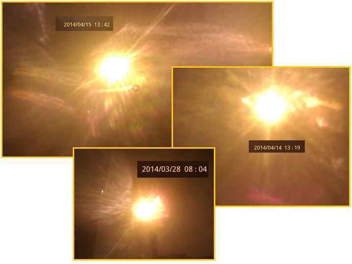
ZetaTalk Explanation
4/19/2014: Alberto
has noted a change in his photos. There seems to be a distinct
orb at the 4 o’clock position on an April 15 photo, which is
itself reflecting sunlight as though it were partway between
the Sun and the Earth. Is this Planet X itself? Unlike the
Moon Swirls, which can focus light down a tube as though
coming from the end of a flashlight, the Planet X halos are
caused by an even distribution of light from the corpus
itself. The shroud of dust clings closely, but rapidly becomes
less thick at a distance from the corpus. At various points
where the composition of this shroud changes, a ring is formed
that will reflect and diffract light outbound from the corpus
of Planet X.
|