|
Global Swelter
Iran was in the news in early August with an almost unlivable
heat index – 165F. Higher base temps have been reached, for
instance in Death Valley California, but combined with humidity
some cities in Iran were breaking all records. Plastic melted.
Eggs fried on the sidewalks. And people were dying.
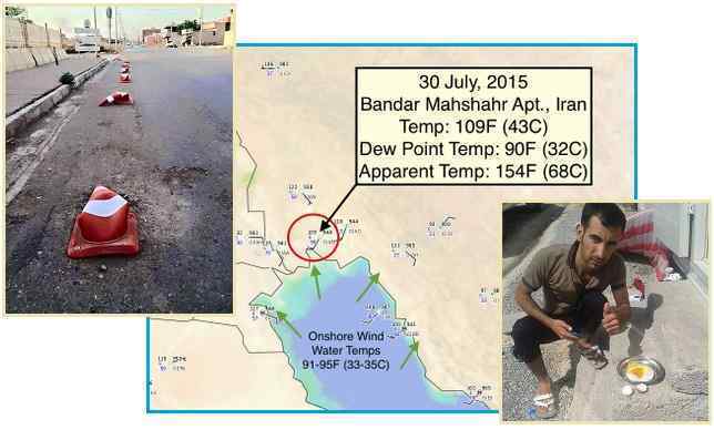
- Iran is literally melting – Amazing
163 F (73 C) in Bandar Mahshahr
August 1, 2015
http://strangesounds.org/2015/08/iran-is-literally-melting-amazing-163-f
- People can cook their eggs under
the sun.
- Scorching 'Heat Dome' over Middle East
makes it Feel like 162F in Iran
August 1, 2015
http://www.telegraph.co.uk/news/worldnews/middleeast/iran/11777843/Scorching-heat-dome
- The word "hot" has taken on an
entirely new meaning in Iran's city of Bandar Mahshahr,
where it was claimed that the city's heat index, or
"feels-like temperature", was among the highest ever
recorded. It is just a few degrees lower than the highest
ever recorded heat index, which was 178F (81C) in Dhahran,
Saudi Arabia on July 8, 2003. Scorching heat levels of 50C
have already paralysed nearby Iraq, where officials were
forced to call a four day public holiday because it was
too hot to work. The heat index was recorded by a
group of astonished weather experts who predict the
country could be enduring some of the hottest urban
temperatures ever endured by mankind. The dome - a type of
high pressure ridge that is passing over the region - has
exacerbated electricity and water supply issues and makes
the scorching heat even more unbearable. Highest ever
temperatures: 56.7C at Greenland Ranch, Death Valley,
California, USA on July 10 1913
Iran was not alone, as India, Pakistan, and much of Europe had
been suffering under undue heat in June and July.
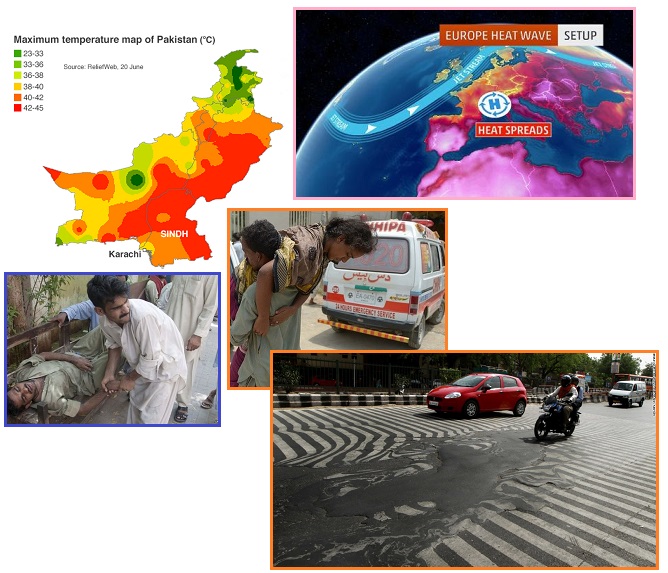
- Pakistan Heatwave: Death toll Crosses
800 People in Sindh
June 26, 2015
http://www.bbc.com/news/world-asia-33236067
- As temperatures reached 45C
(113F), Pakistan's PM Nawaz Sharif called for emergency
measures and the army was deploying to help set up heat
stroke centres. There is anger among local residents at
the authorities because power cuts have restricted the use
of air-conditioning units and fan. Matters have been made
worse by the widespread abstention from water during
daylight hours during the fasting month of Ramadan. The
all-time highest temperature reached in Karachi is 47C,
recorded in 1979.
Last month, nearly 1,700 people died in a heatwave in
neighbouring India.
- Heat Records Shattered in Germany,
France, the Netherlands in June/July 2015
July 8, 2015
http://www.weather.com/forecast/news/europe-heat-wave-record-highs-june-july-2015
- The culprit for this heat wave was
an area of high-pressure aloft nosing northeastward from
the Iberian peninsula into parts of northern Europe. Under
this dome of high pressure aloft, dry, sinking air and
generally light winds allowed stifling heat to build.
- India Heat Wave Kills 2,330 People as
Millions Wait for Rain
June 2, 2016
http://www.cnn.com/2015/06/01/asia/india-heat-wave-deaths/
- Temperatures hit a high of 48
degrees Celsius in some cities last week -- that's 118
degrees Fahrenheit. A week ago, it was hot enough in
Delhi, in the north, to melt roads.
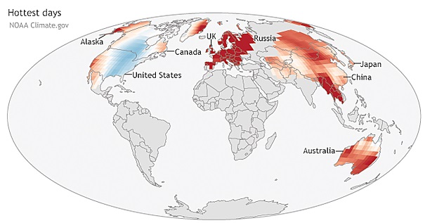
In fact, Australia, South America, the American west, China
and many other parts of the globe had also been enduring heat
spells. But why the distinct cool spot over the northeast United
States and Quebec, and in the waters surrounding Greenland?
- June, First Half of 2015 Break Old
Records by far as Earth keeps Heating Up
July 20, 2015
http://www.usnews.com/news/science/news/articles/2015/07/20/another-month
- June was warm nearly all over the
world, with exceptional heat in Spain, Austria, parts of
Asia, Australia and South America. Southern Pakistan had a
June heat wave. In May, a heat wave in India claimed more
than 2,000 lives and ranked as the fifth deadliest on
record. Earth has broken monthly heat records 25 times
since the year 2000, but hasn't broken a monthly cold
record since 1916.
- Global Temperature Records Just Got
Crushed Again
April 17, 2015
http://www.bloomberg.com/news/features/2015-04-17/this-has-been-the-hottest
- Results from the world's top
monitoring agencies vary slightly. NOAA and
the Japan Meteorological Agency both had March
as the hottest month on record. NASA had it as
the third-hottest. All three agencies agree that the past
three months have been the hottest start to a year. The
heat was experienced differently across the world. People
in the U.S. and Canadian Northeast had an unusually cool
March. But vast swaths of unusually warm weather covered
much of the globe, and records were broken from California
to Australia.
- Update on Global Climate Highlights
July 23, 2015
http://www.accuweather.com/en/weather-blogs/climatechange/update-on-climate-change
- Days with high temperatures warmer
than 90 percent of the 1961-1990 record are considered
warm days. Nights with low temperatures in the bottom 10
percent of the temperature record are considered cool
nights, according to Muchon Scott of NOAA. The warm days
map shows areas where the frequency of warm days in 2014
was higher than the 1961-1990 average and areas where they
were lower in blue.
Per the Zetas, the Earth wobble has changed to lean more to
the right and left during its daily Figure 8 pattern, thus
bringing much of the globe to the heat experienced by the
Equator. The effective latitude of lands both North and South
has been changed during the wobble, as the globe is laid out
somewhat sideways rather than straight up and down. Those who
doubt this should take an accurate meaure of their sunrise and
sunset locations, as well as the position of the Sun overhead in
the dome at noon, and compare these measures to what a simple
planetarium program such as Skymap
or Stellarium
anticipate.
ZetaTalk Explanation
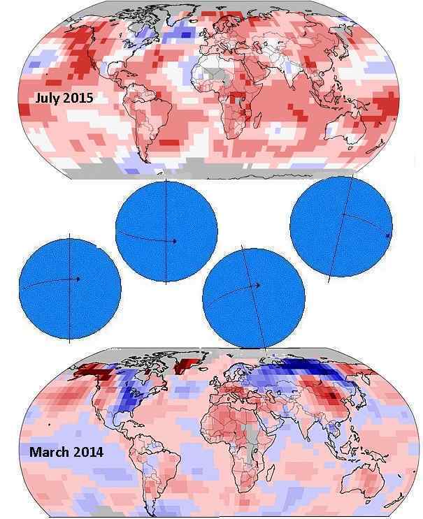
8/8/2015: Comparing
the heat map from 2014 to 2015, one can see that heat has
increased across the globe. These maps are showing the
variance from average temps for the time of year, not the
temps themselves, thus the fact that the 2014 map was taken in
March and the 2015 map in July is irrelevant. The reason so
much of the habitable globe - the temperate and tropical zones
- are showing this increase overall is due to a change in the
Earth wobble. The daily Figure 8 is still in process, but the
tilt to one side and then the other have become more extreme,
thus laying the habitable parts of the globe under more
intense sun for a longer period of time.
The daily Figure 8 of the
wobble includes a Polar Push, whereby the magnetic N Pole of
the globe is pushed back over the horizon when it rolls around
to face Planet X, aka Nibiru. This still occurs, when the Sun
is over the Pacific, though because Nibiru is now positioned
more to the right of the Earth, this push away occurs when the
Sun is overhead at noon closer to N America than previously.
This shift due to the position of Nibiru was present in early 2014 for our last Weather Wobble
analysis. Comparing 2014 and 2015, we see:
- Tilt to the Right: In
2014 heat increased in China as it was exposed to more
sunlight when the magnetic N Pole tilts to the right. This
heat increase is still there for China in 2015 and has
increased to include the Indian ocean and the ocean to the
east of Australia. In 2015 the tilt to the right has become
more extreme and thus an Equatorial sun is blasting a larger
part of the globe.
- Tilt to the Left: In
2014 heat increased in Europe when it was exposed to more
sunlight and was under a high pressure dome when the
magnetic N Pole tilted to the left. This is still the
situation in 2015.
- Polar Push: In 2014 both
Russia and Siberia were registering more cold as the Polar
Push had gotten more extreme. Russia and Siberia spend more
time with less sunlight, thus. In 2015 this has changed, as
the Polar Push has given way totilt a more extreme to
this or that side, which effectively hides the magnetic N
Pole of Earth from the blast of magnetons from Nibiru’s N
Pole.
- Polar Vortex: In 2014
eastern US and Canada had endured a Polar Vortex winter as
this part of the globe is on the opposite side of the globe
from Siberia, where the magnetic N Pole now resides. When
the Polar Push occurred, noon over the eastern Pacific, N
America was pushed under Arctic air. In 2015 this
Polar Push had eased, as the tilt to the right and left had
increased instead. But cold still flows from the Arctic as
the more violent and extreme tilt to the left is pushing
Quebec under Arctic air and forcing a daily gush of cold
ocean currents around the sides of Greenland.
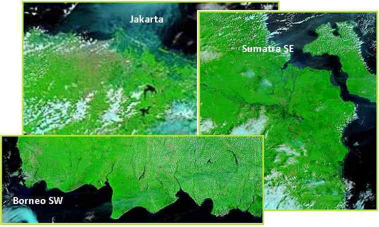
Asia Sinking Denial
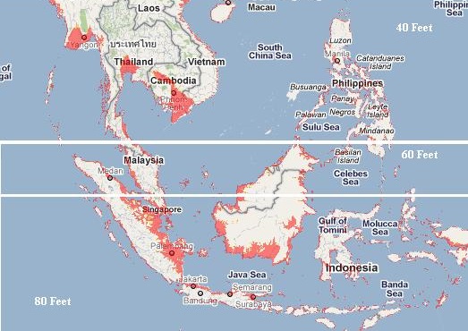
The 7 of 10 plate movements started in
early 2011, and sinking was notable to the level predicted
by the Zetas on the MODIS satellite images
in early 2012. The Zetas stated on February 2, 2013 that
the sinking of the Sunda Plate was only 70%, then on March 7,
2015 that it had progressed to 93%, and just recently on August
1, 2015 that it was now 95% complete. Recent news articles have
confirmed continued sinking. Why then do the MODIS images not
show this progress? Per the Zetas, there is a MODIS cover-up in
process. Old land images are being used, so that only the
passing cloud cover is current.
ZetaTalk Insight
8/8/2015: 7
of 10 was an extreme threat to countries on the Sunda Plate.
Indonesia, Malaysia, Cambodia, Viet Nam, Thailand – all
were loath to confess to their populace that soggy lands being
inundated by sea water was not only a permanent blow, but that
the situation would worsen with the passage of Nibiru.
Flooding was blamed on rain, despite the incursion of sea
water. Sea walls were strengthened and villages relocated, and
any honest reporting by journalists suppressed. In that
Nancy was using MODIS satellite images to prove her point, and
did so dramatically by early 2012, the southeast Asian
countries wanting to suppress awareness of what was to come
sought to modify the MODIS story.
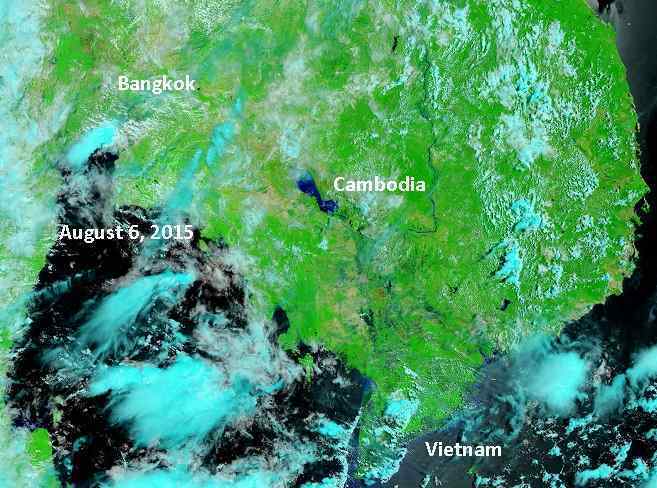
By early 2012 MODIS was
showing sinking in Bangkok, Viet Nam, and Cambodia to the
level we predicted – a loss of 40 feet. Bangkok in particular,
being a tourist attraction, was frantic to reverse the
perception that they were sinking. The recent admission that
Bangkok is sinking and may be under water in 15 years is an
attempt to connect their brave front with reality. In order
for MODIS to reflect a false land mass under a changing cloud
cover for Thailand, this needed to be put into place for
neighboring Cambodia and Viet Nam too. Yet the flooded Myanmar
Delta now requires international aid. Such is the living lie.
Indeed, by early 2012 MODIS showed Viet Nam and Cambodia and
land surrounding Bangkok flooded to the 40 foot depth predicted
by the Zetas. Whether this was inland or along the coastlines,
this was the depth!
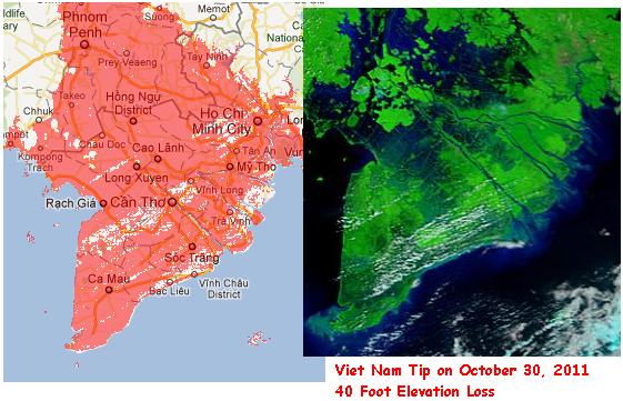
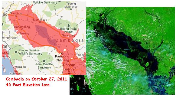
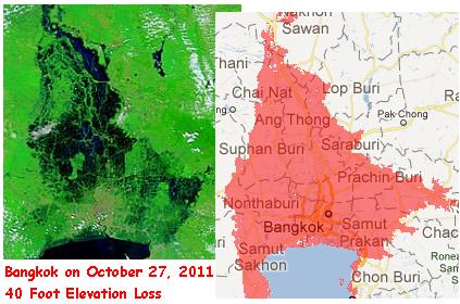
This sinking was heavily denied, but now we hear a tepid
admission. Bangkok must move. In addition flooding in nearby
Myanmar will require international aid! Yet the MODIS view of
these lands shows that the sinking evident in 2012 has
disappeared!
- Bangkok Is Sinking and May Be
Underwater in 15 Years, Study Says
July 27, 2015
http://www.weather.com/science/environment/news/bangkok-sinking-subsidence-warming
- A new report from Thailand's
government says that Bangkok, its capital city and home to
some 14 million people, could be underwater in the next 15
years thanks to a combination of sinking land and rising
global sea levels.
- Water Rises Dangerously in Flood-Hit
Myanmar's delta; U.S. to Help
August 5, 2015
http://www.reuters.com/article/2015/08/05/us-myanmar-storm-id
- Residents of Myanmar's low-lying
delta region were bracing on Wednesday as flood waters
from the north of the country began to flow into the area,
pushing river levels dangerously high.
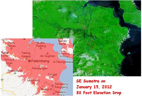
Those parts of the Sunda Plate further south predicted to
experience a 60 to 80 foot loss in elevation likewise showed
this depth of loss in early 2012. But the cameras seemed frozen
at that date! Per the Zetas, the establishment in Indonesia and
other nearby countries felt they could not walk back the press
or the Internet chatter, but could freeze the story MODIS told
at that point.
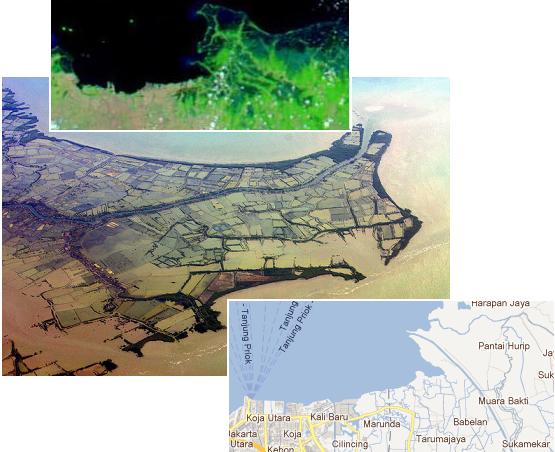
ZetaTalk Insight
8/8/2015: Further
south, where Jakarta was having serious problems with sinking,
a similar story was developed. The city streets of Jakarta
were awash, pumps attempting to push the water over sea walls,
and where this news was denied as anything but a problem with
rain swollen rivers, photos from air travelers proved
otherwise. Reports were floated that Jakarta was sinking
only because aquifers were being drained by city dwellers, and
experts were called in from the Netherlands to help strengthen
the dykes.
Indonesia opted not to deny what had already been in the press
or in Nancy’s newsletters, but the sinking story as presented in
MODIS was frozen at the early 2012 level. Yet we hear that
Jakarta must move to Borneo and that the Kuala Lumpur new
airport, which is in the sinking zone, has now become a
disaster. Construction on this new airport was started in 2009,
ahead of when our 7 of 10 sinking predictions became public in
2010. Now in 2015 the sinking has made using the airport nearly
impossible, due to constant puddles on the runways.
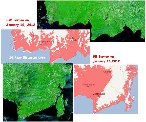
One can see from the current MODIS images that the sinking
present in early 2012 was not removed, but left in place. Not
only is Indonesia announcing its capital will be moving to
Borneo, Kuala Lumpur in Malaysia has a disaster in their new
airport, constructed in the sinking zone. Oops.
- Jokowi Government Wanted to move the
Capital to Sampit or Pangkalan Bun
April 7, 2015
http://www.merdeka.com/peristiwa/pemerintah-jokowi-mau-pindahkan
- Government Jokowi still preparing
the transfer of the capital city of Jakarta Special
Capital Region to another city. The government calls
Borneo island an ideal place for the transfer of the
national capital. Since the era of President Sukarno, had
been under consideration in 1957 that the city of
Palangkaraya, Central Kalimantan, as the transfer of the
capital city of Jakarta. Minister for National Development
Planning / Head of National Development Planning Agency
Andrinof Chaniago revealed Palangkaraya no longer worthy
to be the capital because the carrying capacity of the
land is not adequate.
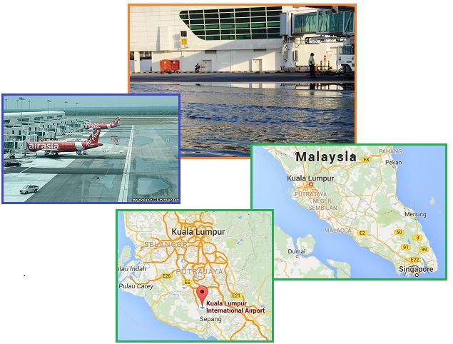
- Kuala Lumpur’s $1 Billion Terminal Is
Sinking, Airline Says
July 27, 2015
http://www.bloomberg.com/news/articles/2015-07-26/kuala-lumpur
- “The airport is still sinking,”
Aireen said. The operator, Malaysia Airports Holdings
Bhd., “has done some partial resurfacing, but what the
airport actually needs is a permanent solution.”
Where is this all heading? Per the Zetas, the false bravado
and public denial will continue because there is no country
willing to take the people on the Sunda Plate and nearby India
as immigrants. They have been rebuffed by Australia and China,
and not welcomed by any other countries either. One does not
give the people bad news unless one can tell them what to do about it, and at
present, this avenue does not exist. Meanwhile, Indonesia and
India present their credentials as booming economies.
ZetaTalk Insight
8/8/2015: Will
the future bring more honesty? We are told, in the press, that
Indonesia is the next China, an economic
miracle about to
flourish. With no country willing to take immigrants from
Indonesia, such will continue as the living lie.
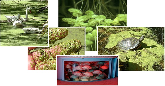
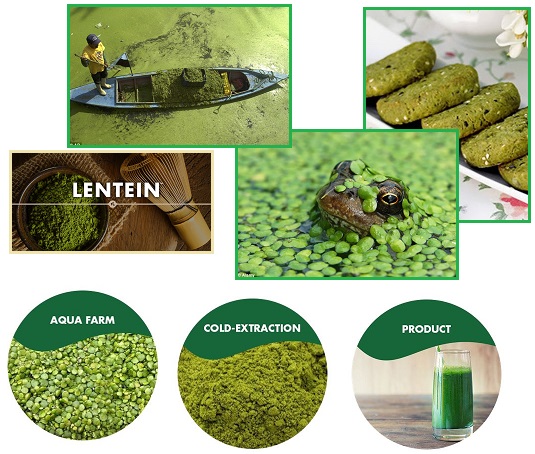
Ode to Duckweed
Duckweed has been featured before in this newsletter, in Issue
292 in 2012. In addition to being a high protein salad
food for human consumption, Duckweed can feed Tilapia fish, an
excellent domestic fish grown in ponds and tanks. Able to
flourish in polluted waters, where it picks up the nutrients
needed for growth, it is an overlooked food source for the
Aftertime.
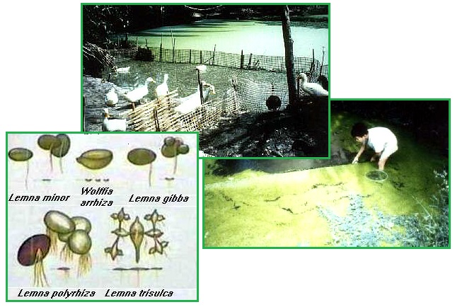
- Duckweed
http://www.naturia.per.sg/buloh/plants/duckweed.htm
- Duckweed is the smallest flowering
plant. It floats on the water surface in a bright green
layer. Duckweed has no stems and no leaves. Some may have
tiny roots. Duckweed is found almost everywhere
except permanently frozen poles and driest deserts.
Duckweed have the highest growth rate of any higher plant.
Duckweed is eaten by people in Thailand. By absorbing
nutrients, Duckweed also has potential as a natural water
purifier, converting waste water and sewage into pure
water and edible Duckweed.
Duckweed is promoted as fodder for animals when grown in
polluted waters such as sewage effluent or fertilizer runoff
from fields. Alga also grows in such water ways and can be fed
to domestic animals, but duckweed grows just as well and is more
easily harvested. Both algae and duckweed have the potential to
be human food, but duckweed is higher in protein.
- Duckweed: A tiny Aquatic Plant with
Enormous Potential for Agriculture and Environment
http://www.fao.org/Ag/againfo/resources/documents/DW/Dw2.htm
- Duckweed grows on water with
relatively high levels of N, P and K and concentrates the
minerals and synthesises protein. These are the nutrients
which are often critically deficient in traditional
fodders and feeds given to ruminants and to pigs and
poultry. Duckweed aquaculture is an activity that fits
readily into many crop/animal systems managed by small
farmers and can be a major mechanism for scavenging
nutrient loss. It appears to have great potential in
securing continuous food production, particularly by small
farmers, as it can provide fertiliser, food for humans and
feed for livestock and in addition decrease water
pollution and increase the potential for water re-use.
There is immense scope to produce duckweeds on industrial
waste waters, providing a feed stock particularly for the
animal production industries, at the same time purifying
water.
Now this amazing little water plant can be harvested, dried,
and ground into a powder for long-term storage. Called Lentein,
it is higher in protein than milk and soy based protein powders.
- Is Duckweed really the Food of the
Future?
Weed that Chokes Lakes is High in Protein and could Help
Solve World's Food Crisis
July 15, 2015
http://www.dailymail.co.uk/news/article-3161555/Is-duckweed-really-food-future
- Duckweed – the little green dots
that rapidly blanket water - may not look appetising but
they are very high in protein in their raw state
containing 45 per cent compared to 36 per cent for soy
beans. Known as 'water lentils' in France and Spain,
experts at a food technology conference in Chicago have
revealed a method of drying the duckweed and grinding it
into a high-protein powder. The resulting super-food,
which is green, is known as Lentein and contains 68 per
cent protein as well as fibre. It could eventually replace
food products like whey powder made from milk and soya as
a healthy, vegan alternative. It is gluten and
lactose-free and not genetically modified in any way.
- Lentein
http://www.lentein.com/
- LENTEINTM is a unique high-protein
food product containing the nutritional qualities of water
lentils. Grown in an aqua farm and extracted through a
cold-water process, this incredible protein-packed plant
powder has the capability to positively impact both an
individual’s nutrition and the world’s food supply.
|