7 of 10 Drum Roll
The Zetas have predicted that the 7 of 10 scenarios will start by the end of 2010, with at least one of them, and possibly
more, playing out by that date. They have also given the sinking of the tongue holding Indonesia as the first scenario,
accompanied by a slight tilting of the Indo-Australian Plate, which they describe as the brake point during global plate
movements. When the Indo-Australian Plate moves, it allows other plates to likewise move, in a domino fashio. So
what are the signs that this part of the globe is about to have plate movement? First, the already volcanically active
Indonesia region has become more active.
- 21 Volcanoes Across Country Ready to Erupt
October 01, 2010
http://www.thejakartaglobe.com/indonesia/21-volcanoes-across-country-ready-to-erupt/399206
- An official from the Volcanology and Geological Disaster Mitigation Agency (PVMBG) told the Jakarta Globe
on Friday that the alert for 18 volcanoes had been raised from Level 1, or "normal," to Level 2, or "beware." All
21 volcanoes highlighted have erupted sometime this year, and are among 59 active volcanoes across the
country.
Second, more signs that the ground under Java is shifting. Not just sinking, as noted earlier in Issue 204 of this
newsletter, but shifting so that the tracks and controls along rail lines are affected. Within an hour of each other, two
trains wrecks occurred in Java. As someone noted, this could not be merely a coincidence.
In the wee early morning hours of this October 2, 2010), two as yet unexplained train accidents
occurred within one hour of each other on the Indonesian island of Java. These two accidents
were at least 70+ miles apart. Both train accidents occurred in the Central Java area, north of,
but not too far from the Java Trench portion of the tectonic plate juncture where the
Indo-Australian plate meets the tongue of the Eurasian plate. Both train accidents appear to
have occurred at or near the northern coastal side of the central portion of the island of Java. In
other words, the same side (northern) of the island where Jakarta sits.
One of the train wrecks was in Jakarta, and the other in Solo, nearby.

- Indonesia train wreck kills at least 36
October 2, 2010
http://www.statesman.com/news/world/indonesia-train-wreck
- A train crashed into another parked at a railway station in central Indonesia, killing at least 36 people and injuring
dozens. Investigators were trying to determine whether human error was to blame. Indonesia has a reputation for
poor safety standards and maintenance. Just an hour after Saturday's collision, another train crashed in the town
of Solo, also in Central Java, killing at least one person.
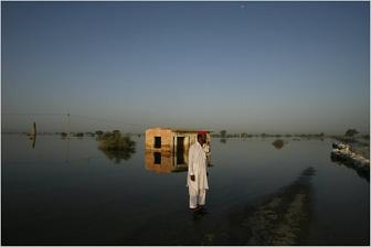
Meanwhile, the plate holding India and Australia continues to tilt. The flooding in Pakistan, along the Indus River (which
is the western edge of the plate) is not draining, as noted in Issue 201 of this newsletter. Now two months after the
flooding, this is still the case! As the Zetas state, the Indus River valley has lost elevation.
- On Our Radar: Floodwaters Persist in Pakistan
October 5, 2010
http://green.blogs.nytimes.com/2010/10/05/on-our-radar-floodwaters-persist-in-pakistan/
- In low-lying Sehwan, Pakistan, home of the country's largest Sufi shrine, floodwaters from this summer's
devastating storms are draining slowly, or not at all. Malnutrition and illness are rife, and on the city's outskirts,
roving bandits loot abandoned villages, which remain completely surrounded by water.
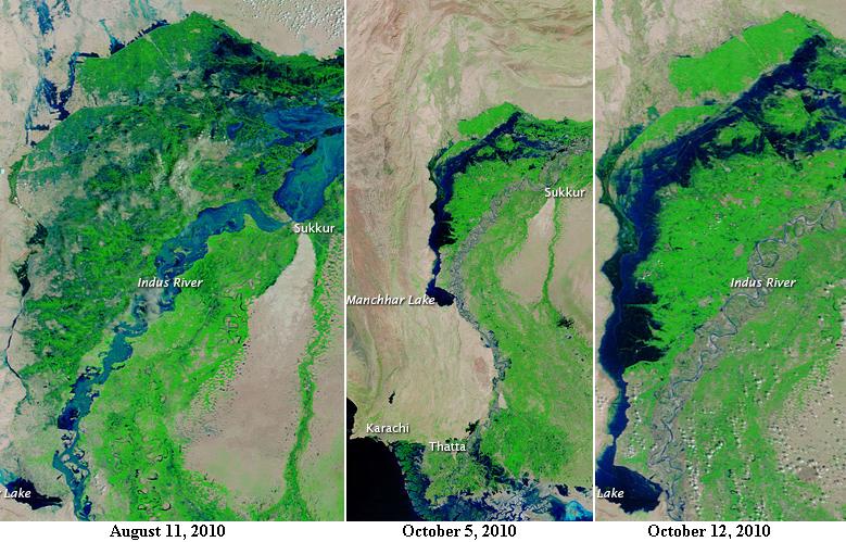
Per Earth Observatory photos, an inland lake developed just west of the Indus River. The cover-up excuse for this
appearance of a huge inland lake is that "apparently" the Indus River waters had become trapped behind levees at the
Mancchar Lake. But on September 20, 2010 this lake at the end of the supposedly trapped waters was expected to be
drained of floodwaters in 35 days, by October 25. Yet no draining has occurred, but instead the flooding in Manchhar
Lake has increased! The land there has been dropping in elevation.
- Flood Lake Lingers in Pakistan
October 12, 2010
http://earthobservatory.nasa.gov/NaturalHazards/view.php?id=46369
- Even though water levels fell along the Indus, the floodwater west of the river basin remained trapped.
The Moderate Resolution Imaging Spectroradiometer (MODIS) on NASA's Terra satellite show part of the
Indus River Basin. Images use a combination of infrared and visible light to increase the contrast between
water and land. Vegetation is bright green. Bare land is pink-beige. Clouds are pale blue-green. Water
ranges in color from electric blue to navy. The image from October 2010 shows the lingering floodwater
lake west of the Indus. Apparently trapped by levees that were unable to prevent flooding, water rests on
what would normally be dry land, leaving nearby communities underwater.
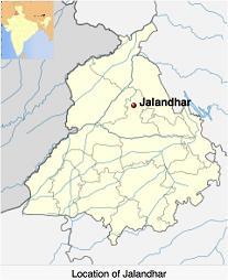
There are more signs that the plate housing India is on the move. Above the Indus River valley, up where the plate
housing India abuts the Himalayas, the village of Jalandhar began shaking and did not stop shaking for two weeks.
- Continuous Tremors Shake Indian Village
October 6, 2010
http://english.ntdtv.com/ntdtv_en/ns_asia/2010-10-06/733710429010.html
- Earthquake tremors have been shaking the village of Jalandhar in India's western state of Gujarat for more than
two weeks.
VIDEO: http://www.youtube.com/watch?v=UgIXEZa4LWQ
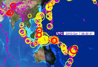
The shaking was reported on October 6, and the October 7 IRIS chart indeed shows this area getting significant
quakes.
Moving east along the upper border of the plate housing India, we find the village of Mamit sinking 20 feet, requiring
most the village to be evacuated.
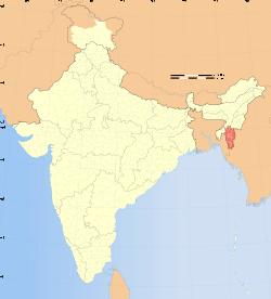
- India town sinks more than 20 feet
October 12, 2010
http://edition.cnn.com/2010/WORLD/asiapcf/10/12/india.sinking.town/index.html?hpt=T2
- A remote Indian town has sunk at least 20 feet, displacing about 250 residents. A small crack first appeared on
the surface of the town of Mamit in the mountainous northeastern state of Mizoram in 1994. The expanding
cavity reached a critical stage this year, forcing authorities to evacuate at least 61 families. The ground caved in
more than 20 feet, he said. Forty-three houses have been dismantled as a precaution. Geologists do not expect
the earth to sink further, but many residents have been granted land in another neighborhood to build anew.
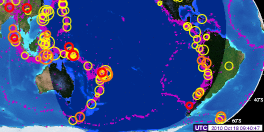
The entire Indo-Australia Plate seems to be loosened up and on the move. By October 18, 2010 the entire eastern half
of the Indo-Australian Plate was outlined with quakes on IRIS. Clearly, the brake point is giving, and the plate is on the
move!
Indonesia Elevations
Just how badly will Indonesia and the other countries housed on the tongue holding Indonesia sink? The Zetas have
indicated that when the brake holding plate movement is released, that this sinking of this tongue will happen suddenly.
ZetaTalk Prediction 10/9/2010: The 7 of 10 scenarios describe plate movements, and for this to occur something
has to release the deadlock, the current stalemate where the plates are locked against each other. Once the
deadlock is broken and the plates start moving, sliding past each other, new points where the plates are locked
against each other develop, but these are weaker locks than the one at present. The current lock, as we have so
often stated, is the Indo-Australian Plate which is being driven under the Himalayans. This is no small lock, as
the height of the Himalayans attests. Nevertheless, the activity in this region shows this likely to be the first of
the 7 of 10 scenarios to manifest. Bangladesh is sinking and the Coral Sea is rising, showing the overall tipping
of the Indo-Australian Plate. Now Pakistan is sinking and not draining its floods as it should, while Jakarta on
the tongue of Indonesia is also sinking rapidly, showing that the tilt that will allow Indonesia to sink has already
started.
On July 8, 2010 the city of Hangzhou along the China coastline was treated to a mothership sighting seen as far south as
the Vietnam Sea.
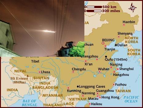
Per the Zetas, residents from Hangzhou south along the China coastline were being warned that they would lose
elevation when the tongue holding Indonesia sinks. Surely this must be a graduated drop, with Sumatra and Java
experiencing the worst of it. The Zetas were asked, and gave a detailed response. The anticipated flooding, which will
be permanent, is show in red on the Goggle Maps below.
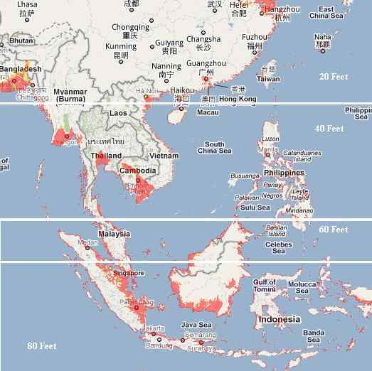
ZetaTalk Prediction 10/16/2010: We have spoken previously of the areas to be affected by the bending of the
tongue holding Indonesia, but can now give more specifics. Draw a line from the city of Hangzhou directly east,
and consider this horizontal line the point of bend. This does not mean that points north can rest easy, as when
the tongue bends down water from various sides will rush in to fill the void, and these waters will have a
rebound in the form of tsunami which can race northward at a height of 20-30 feet. The southern coast of
China was likewise warned that they could experience loss of elevation. How much will their coastline drop,
that they needed this warning from the Hangzhou UFO? This coastline, in general, can anticipate losing 20 feet
in elevation, which will likewise afflict Taiwan though Taiwan is high land and will not be as devastated.
Thought the tipping of the Philippine Plate at first gives the islands of the Philippines some relief, as the
subduction of the plate is pushing under them, as the bending of the tongue holding Indonesia progresses, they
too find an astonishing loss of sea level. However, other than some small islands and the direct coastline, little
of the Philippines will be affected by this rise in sea level, and safety can be gained if the coastal residents head
for the hills at the first sign of sinking. Tsunami will affect the Philippines, to a potential height of 40 feet, so a
prompt evacuation to be at least 20 miles inland is necessary. If the coast of southern China will lose 20 feet in
elevation, the Philippines will ultimately lose twice that much, to a total loss of 40 feet in elevation. Due to the
tilting of the Indo-Australia Plate, Bangladesh gains temporary relief from the steady sinking it has experienced
the past few years. And the tsunami likely to race northward will not come their way because the waters from
the Bay of Bengal will be rushing into the South China Sea, and there clashing to push north. If the loss of 40
feet in elevation is not devastating to the Philippines, it is to the coastline of southern Burma, Tailand, and
Cambodia, which have vast areas that will suddenly and permanently be flooded.
It is the southern tip of the tongue which is utterly devastated. Draw a line just north of the Malaysia border
and over the top of Borneo. The land on the tongue from this point south will double its elevation loss, so that
Java and the islands bordering the Banda Sea will find they have lost a full 80 feet in elevation, sinking many
coastal cities and small islands out of sight. Singapore will be awash, its streets hopelessly inundated. Vast
areas of the northern coastline of Sumatra and the southern coastline of Borneo will likewise be inundated. And
if having the sea rush in were not horrific enough, the sudden drop in elevation will bring with it water from the
Indian Ocean and the Philippine Sea which will create turmoil, unpredictable waves that clash and boil. There
is no predictor indicating that the bend and drop are about to happen that we could point to. There are, as we
mentioned there would be, indicators of the direction that the plates are being pushed, as Jakarta has been
sinking, Pakistan sinking, and the Coral Sea floor rising. We are telling you your coastlines are not safe, and
the rest is up to you!
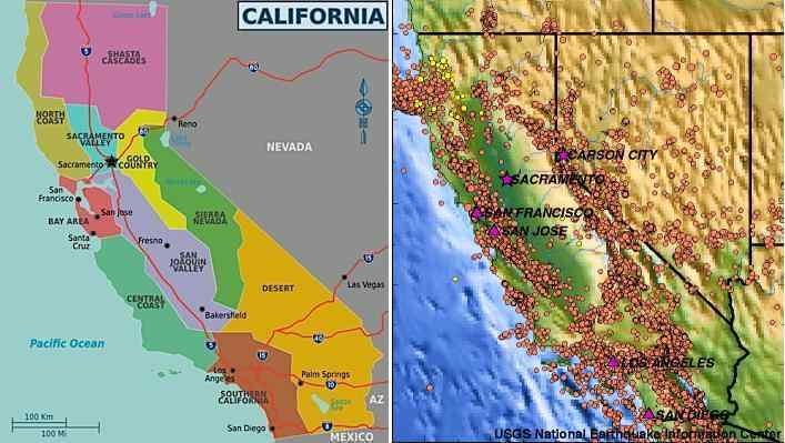
Sierra Scramble
Since mountain building can potentially occurs throughout the N American continent anywhere to the west of the
Continental Divide, those living there are understandably distraught to find a spot to stand on during the hour of the pole
shift. The Zetas have long stated that the Salt Flats will not shatter, and show that they have withstood mountain building
in the past. The Zetas have also pointed out other salt lakes regions in the west, detailing many such spots in Issue 205
of this newsletter. But for those along the long California coastline, where the water rushing in from the compressing
Pacific will rush through the coastal mountains and on in to flood the inland valley, there seems to be scare comfort. The
Sierras are predicted to be rocky during the pole shift!
ZetaTalk Prediction 2001: The mountains on the West Coast of the US in general will be hot and rugged, with
much upheaval, during the shift. The Sierras have been created because of subduction of Pacific plates under
the lighter land mass, and these matters are never a gentle process. Snapping, sudden jolts, and bouncing rock
stratas reacting to a sudden release of pressure can be expected all along the Sierras. The mountains and
valleys have been formed because of crumpling, horizontal pressure, and this will happen again during the
forthcoming shift. What happens to rock when it is asked to compress, to fold? It breaks, and moves into the
point of least resistance which is upward into the air. Thus, jutting peaks of sheer rock with the rock strata
going almost vertical. It crumbles, with a jumble of rock rolling over each other as the mass is pushed upward.
Thus, anyone or anything on top of that spot will be subject to being ground up in the tumbling process.
Compressed rock can also drive horizontally, into nearby soil or space not occupied by anything as dense as
itself. Thus, those in a valley can find rock shooting out of a hillside, or rock spear shooting under their feet,
unexpectedly. Surviving the mountain building process while in the mountains is precarious, and not advised.
Can't ride it out in the Sierras, can't be in the inland valley as it will flood, can't be in the coastal mountains as tidal bore
will likely get you. What to do?
I have been researching on which safe locations have the least risks. The Sierras in California is
vast. I am concerned about picking the wrong spot for those who choose to come with me. Is
there any way you can be a little bit more specific on what part of the Sierra would be the safest
from mountain building? North, South, or Central Sierras? Is this too specific?
The Zetas had an excellent suggestion! Don't forget your running shoes, your hiking boots, and the wheelchair for
granny. It's the Sierra scramble!
ZetaTalk Advice 10/02/2010: Regarding which part of the Sierras will be safe from mountain building during
the hour of the pole shift - we do not have good news. This stretch of rigid rock snaps under compression from
the Pacific, as the high sharp mountains show. Mountain building will occur throughout the Sierras. For those
with homes in the Sierras, who wish to return to them after the pole shift, we have two suggestions. Travel into
Nevada and ride out the pole shift on one of the former salt lake beds of Lake Lahontan, and then return to the
Sierras, or drop down into the San Joaquin Valley, which is stable. The valley will flood with water pouring
over the coastal mountains and rushing up along rivers that drain the valley. However, if timed right and
prepared to travel quickly into the foot hills of the Sierras, it would be possible to avoid mountain building. The
hour of the pole shift will involve the globe on the move, and at the end of that hour, plates crashing into one
another. It is not until the end of the hour that mountain building in the Sierras and compression of the Pacific
will start. Water on the move does not move instantly, but is paced. Thus those along the eastern side of the San
Joaquin Valley can wait until the hurricane force winds start to die down, shortly after the big jolts have
occurred, and then trek into the foothills of the Sierras before the flooding of the valley begins to affect them.
During travel through the Sierras one would encounter much destruction of roadways and bridges, and for this
plan to work, one would have to be prepared to travel on foot through potentially hazardous terrain in the
Sierras.
You received this Newsletter because you Subscribed to the ZetaTalk Newsletter service. If undesired, you can quickly Unsubscribe. You
can always access prior Newsletters from the Archives.
|